Research at RIT
Technologies involved in remote sensing have become increasingly important in applications as diverse as medical diagnostics, homeland security, agriculture, human rights monitoring, satellite deployment, disaster management, and Google Earth.
Through its state-of-the-art research labs and partnerships with the world’s foremost imaging companies and institutions, the Digital Imaging and Remote Sensing Laboratory (DIRS) at Rochester Institute of Technology (RIT) plays a major role in advancing this imaging science.
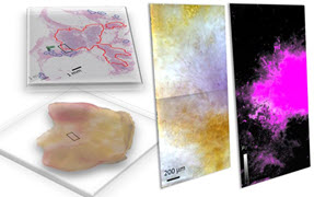
 Hyperspectral imaging provides greatly enhanced imaging accuracy beyond that of normal human vision. On David Messinger’s left screen is an image taken from a hyperspectral image cube of Cooke City, Montana. Vehicles were placed in the town to see if they could be located in the image. Hyperspectral imaging also helps in discerning subtle material properties and differences between surface features. The image on the right screen is a colorized single band of the Cooke City hyperspectral cube highlighting the different materials in the scene.
The lab, housed in the Chester F. Carlson Center, collaborates with faculty and staff throughout RIT’s eight colleges while also partnering with the National Science Foundation, Los Alamos National Laboratory, and Boeing Corp. on more than two dozen separate research projects. Results from these efforts have appeared in a host of journals and have been presented at international conferences hosted by SPIE and others.
One recent collaboration involved SENSIAC, the Military Sensing Information Analysis Center, to improve the rapid collection and processing of imagery using a multiband sensor.
“DIRS researchers were able to quickly collect the imagery, adjust its apparent resolution as needed, and segment the image for further processing and analysis,” says David Shumaker, SENSIAC’s director. “This type of rapid and innovative execution is very rare in the remote sensing field and showcases the lab’s tremendous expertise and capabilities.”
Remote sensing research activities currently being conducted at DIRS focus on both active and passive sensing techniques to develop new equipment, software, and processes. Three main areas are:
• Measurements and phenomenology
• Image analysis algorithm development
• Systems modeling and simulation
DIRS’s phenomenology research has included the development of a host of sensor system packages covering the visible and infrared regions of the electromagnetic spectrum. These devices have been implemented with algorithm-based software packages to enhance image capture, quality, and spectral range, allowing scientists and operators to obtain and analyze images in ways that have not previously been possible.
For example, DIRS developed the Modular Imaging Spectrometer Instrument (MISI) for use in hyperspectral imaging, which captures images beyond the sensitivity of the human visual system. The technique allows for image capture in up to 200 single wavelength bands or colors and provides greatly enhanced imaging accuracy, including the ability to better discern subtle material properties and differences between surface features.

DIRS projects have included a collaboration with NASA and Eastman Kodak to more accurately assess water quality utilizing orbiting satellites. DIRS researchers have worked to implement hyperspectral imaging in the related field of earth observation, using satellites to more properly monitor global anomalies such as climate change.
DIRS Laboratory Director and SPIE member David Messinger and Bill Basener, associate professor in the School of Mathematical Sciences at RIT, are combining the DIRS phenomenology and algorithm development research to improve hyperspectral imaging quality and increase areas of application. Here, mathematical models and algorithms are developed and implemented using imaging devices to locate areas where previously unknown human activity is taking place, as opposed to zeroing in on a specific object, such as a tank or a truck.
The DIRS team believes the process can be used to identify activity where it was not previously known to exist, which would then cue a higher resolution sensor to collect more data. The technology could greatly increase the efficiency of satellite detection devices and have a major impact on the global war on terror.
Messinger’s team was recently awarded a grant from the U.S. Department of Defense to test the technology and ultimately transition the capability to the government for further testing and evaluation.

“Hyperspectral imaging often requires incredibly complex data computations, which reduce the robustness of the system and its ability to pinpoint specific targets,” says Messinger. “The approach being developed here at RIT will utilize the best aspects of the technique in consort with advanced mathematical methods to greatly enhance the overall quality of imagery-based detection systems.”
Messinger is scheduled to present four papers at SPIE Defense, Security, and Sensing in April and will discuss some of the results of this research project.
Similarly, DIRS researchers are making major advancements in the area of modeling and simulation, enhancing their use for sensor and algorithm performance evaluation techniques, which seek to increase the quality of sensor and image production while also enhancing training in the field. The lab has developed a state-of-the-art simulation tool, the Digital Imaging and Remote Sensing Image Generation model, or DIRSIG, to assist in assessing sensing performance.
John Kerekes, associate professor of imaging science, is utilizing DIRSIG in partnership with ITT’s Space Systems Division to analyze the quality of hyperspectral images. The work utilizes simulated images produced by DIRSIG and compares the quality predictions developed by the Forecasting and Analysis of Spectroradiometric System Performance (FASSP) spectral imaging model to the product produced by human analysts assessing the same image.
The process will enhance the performance of quality prediction modeling and assist in improving training of human image analysts. The work also is part of Kerekes’ larger effort to utilize DIRSIG to improve the overall quality of hyperspectral imaging systems.
“This research is designed to provide additional data for enhancing the success of imaging systems from both an equipment and an operator perspective,” adds Kerekes. “It also augments DIRS’s phenomenology efforts in hyperspectral imaging and will ultimately increase the uses of the technology in a host of applications.”
The Digital Imaging and Remote Sensing Laboratory at RIT was founded in the 1980s, thanks to the efforts of John Schott, who now serves as Frederick and Anna B. Wiedman Professor of Imaging Science. A leading international expert in the field, Schott has written numerous journal articles and books on remote sensing, including Remote Sensing: The Image Chain Approach, 2nd Edition.
“DIRS originally grew out of my own interests in remote sensing and the desire to more actively involve my students in hands-on research projects,” notes Schott. “RIT’s well-known expertise in imaging science and its strong relationships with a host of national and international imaging leaders made it a perfect fit for this type of applied research center.”
DIRS students and researchers account for more than $2 million in annual funding at RIT.
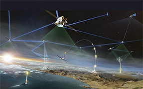
RIT, under the Integrated Sensing Systems Initiative sponsored by NASA, has developed an airborne multispectral mapping system called WASP, Wildfire Airborne Sensor Platform.
Covering multiple spectral bands in the visible and infrared, WASP provides real-time day-night mapping capability with high spatial resolution.
RIT has flown the instrument over wildfires in Montana and Idaho for the U.S. Forest Service, provided near real-time geo-referenced imagery in support of a nuclear power plant disaster drill for the Monroe County Office of Emergency Preparedness, and delivered a near real-time flood plain map to a major utility company.
 Hyperspectral Imaging
 Researchers at RIT are working to implement hyperspectral imaging to monitor climate change and for defense and security applications.
The images at the left show two sample views from their testing in Montana.