Hyperspectral images reveal the extent of submerged vegetation
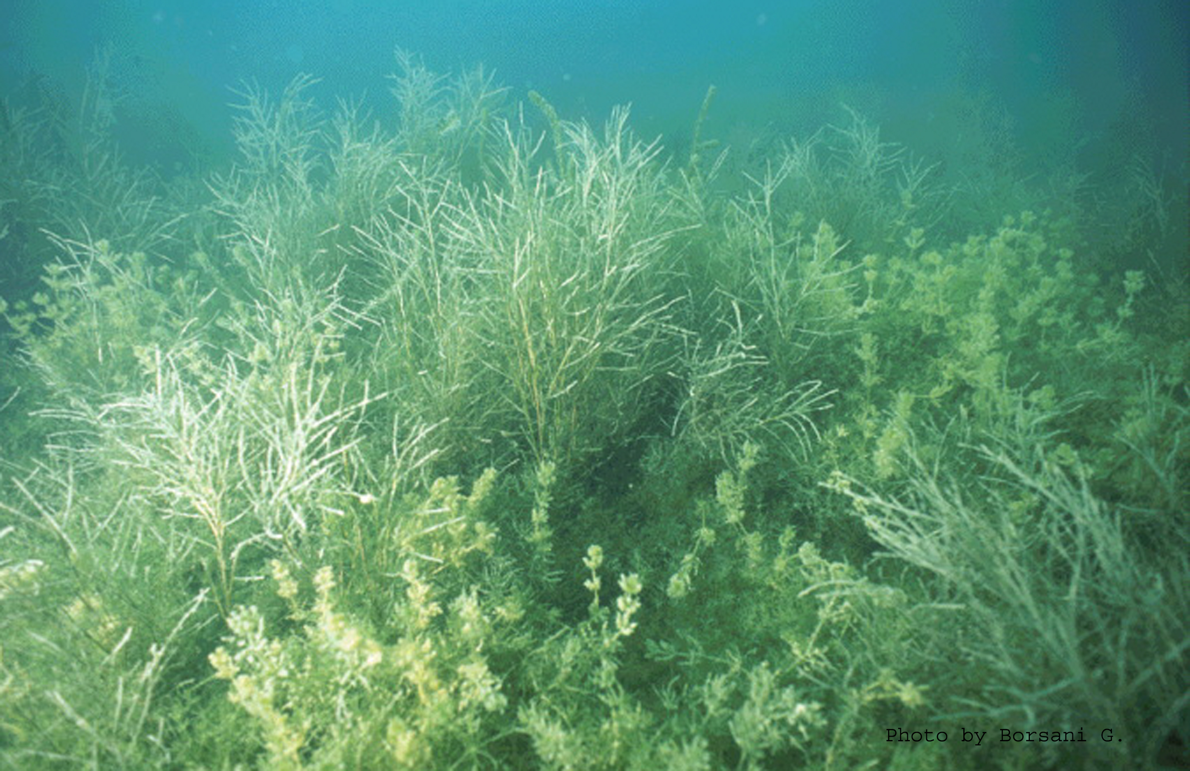
Lake Garda is the largest Italian lake and a major European water reserve. Located in the most densely populated and industrialized region of the country, the lake is a major tourist attraction, thus making the ecosystem ecologically sensitive. The gentle slopes of the southern part of the lake create the ideal habitat for the submerged vegetation of aquatic plants such as macrophytes and common reeds. These play an important ecological role in primary production, re-oxygenation of water and sediments, filtration of suspended solids and heavy metals, and reduction of bacterial loads. Moreover, submerged vegetation both creates a micro-habitat suitable for the life and reproduction of various organisms, and helps defend the coast from erosion. Therefore, assessing the status of these habitats is necessary for ecological monitoring of the lake ecosystem.
Remote sensing techniques acquire detailed information on the characteristics of the Earth's surface. They have been used for large scale inventories of bottom-dwelling photosynthetic organisms such as macrophytes, sea grasses, and corals.1 Radiometric measurements derived from airborne images can be used to estimate bottom albedo, bottom depth, and the amount of various components that contribute to water quality in shallow coastal environments.2
The objective of this study was to use a bio-optical model and airborne images to evaluate variations in submerged vegetation in southern Lake Garda (see Figure 1). The bio-optical model formalizes the relationship between parameters that are estimated from the reflectance spectrum (derived from remotely sensed data) as well as the absorption and backscattering of electromagnetic radiation. To determine the characteristics of both the water column and the bottom of the lake, we used the airborne Multispectral Infrared and Visible Imaging Spectrometer (MIVIS) over Lake Garda.
MIVIS images with a spatial resolution of 5m were acquired in the summers of 1997 and 2005. (Atmospheric correction was accomplished using the 6S code.) We inverted a radiative transfer physical model and applied it to the geo-coded imagery. The bio-optical model was based on one in the literature.3 We performed model parameterization using an extensive dataset of radiometric and limnological field measurements that equated to about 30 days of field campaigns.4 The output maps covered an area of 450ha that was identified at the 7m bathymetry level. (The model used in this study was not sensitive enough to detect submerged vegetation at lower depths.) Each pixel of the maps quantified the proportion of the surface covered by submerged vegetation.
The output maps showed that in the 8-year interval between observations, the extent of submerged macrophytes decreased from 72% to 52%. Field observations in recent years confirm this trend. The decrease in areas covered by macrophytes is an indicator of changes that will lead to a decrease in water transparency because of an increase of phytoplankton chlorophyll and suspended solids. This, in turn, will likely lead to a decrease in fishing, an enrichment of organic matter in the sediments, and a decrease in biodiversity.
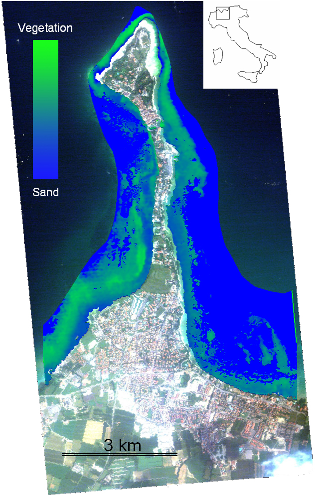
The decrease suggests that this area of Lake Garda is highly sensitive and that human pressure can progressively worsen ecological conditions. Since 1977, environmental laws aiming to protect submerged vegetation have been in place, but these do not seem to have succeeded in protecting macrophyte colonization areas. However, recent studies also based on remote sensing data (both aerial ortho-photos and MIVIS data) 5 highlighted an opposite, increasing trend in the extent of common reed vegetation in the Sirmione peninsula of southern Lake Garda (see Figure 2). Susceptibility to ecological damage is highly dependent on the organism involved, so tracking many different members of an ecosystem is important to obtaining an accurate picture of changes in an area.
Claudia Giardino received her undergraduate degree in environmental engineering and her PhD in geodetic sciences at the Polytechnic University of Milan. Her research interests include the quantitative aspects of optical remote sensing, radiative transfer theory, imaging spectrometry, and calibration/validation activities. Most of her work has focused on water resources assessment and bio-physical parameter retrieval. In 2004 and 2006 she was a visiting scientist at the Commonwealth Scientific and Industrial Research Organisation, Land and Water Division, Canberra, Australia.
Mariano Bresciani is a naturalist specializing in aquatic vegetation. He is involved in field campaigns for chemical, biological, and radiometric data acquisition. He also manages reed habitats and monitors inland water environments. Bresciani teaches environmental education and remote sensing.
Daniela Stroppiana received her undergraduate degree in environmental engineering from the Polytechnic University of Milan. She is currently involved in natural vegetation and agriculture monitoring. She worked for the Istituto Agronomico per l'Oltremare of the Italian Ministry of Foreign Affairs in Florence and the European Commission's Joint Research Centre in Ispra, Italy.