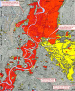
Images show Pakistan disaster
SPIE Newsroom
2 September 2010
Satellite data from around the world are being used to generate essential maps of the floods in Pakistan that have affected up to 20 million people. Data from a range of Earth observation satellites are being used, both through the International Charter Space and Major Disasters and the Global Monitoring for Environment and Security (GMES) initiative, to provide mapping for emergency response.
 Maps generated via the Charter are essential because they use the very latest satellite imagery to show exactly how far the flood waters have spread, enabling rescue teams on the ground to identify the best way to access those stranded and in need. This is especially important because this year's flood has affected such a vast area, estimated at a third of the country.
Typically, maps are created using radar imagery such as that acquired by Envisat's Advanced Synthetic Aperture Radar 'ASAR' (right), which can see through cloud and darkness, as well as from optical instruments such as Envisat's Medium Resolution Imaging Spectrometer Instrument 'MERIS' or the French Spot 5 satellite.
The European Space Agency's new Soil Moisture and Ocean Salinity (SMOS) satellite was used to map the saturated soils in Pakistan. SMOS, launched in November 2009, carries an 8m-wide interferometric radiometer that senses the natural emission of microwaves coming off the surface of the Earth and then images brightness temperature. Variations in the sogginess of the soil modify the signal, providing data for maps of soil moisture and ocean salinity.
Mapping services are also being provided through NASA and the GMES Services and Applications for Emergency Response 'SAFER' project, which uses timely satellite data to deliver rapid mapping services for disaster management. SAFER is a consortium of 55 European partners to provide support for all types of disaster. Apart from Pakistan, recent services have been provided for flooding in BurKina Faso in west Africa, floods in Bulgaria and floods in Moldova.
NASA's CloudSat satellite captured the genesis of the flooding event as it flew over the region on 28 July. At that time, a large area of intense thunderstorms covered much of Pakistan. Between July 28 and 29, up to 400 millimeters (16 inches) of rain fell from these storm cells, triggering flooding along the Indus and Kabul Rivers. Storms with similar structures to this one were common this summer as tropical monsoon moisture, coupled with a strengthening La Nina (which has different effects around the world), dominate this region's weather patterns.
Other NASA satellites and instruments used in the relief effort:
- NASA's Aqua spacecraft
- Atmospheric Infrared Sounder (AIRS)
- Advanced Microwave Sounding Unit
- Moderate Resolution Imaging Spectroradiometer (MODIS)
- NASA's Terra spacecraft
- Advanced Spaceborne Thermal Emission and Reflection Radiometer (ASTER)
- Multi-angle Imaging Spectroradiometer (MISR)


