Public-health applications in remote sensing
Remote sensing of the environment is critical to warn of imminent, life-threatening dust storms and to reduce risk of exposure to desert dust and hitchhiking bacteria, molds, heavy metals, and other human-health concerns. Desert dust affects cardiovascular and respiratory illness. Respirable particulates result in health-care costs exceeding $11.5 billion annually, with an additional $4.6 billion for lost productivity.1
As part of the NASA-sponsored Public Health Applications in Remote Sensing (PHAiRS) project, data from NASA's Terra satellite are assimilated into a numerical-dynamical model of dust generation and entrainment, DREAM (Dust Regional Atmospheric Model). Originally developed for the Mediterranean region2 and modified in PHAiRS for the southwestern United States,3 DREAM is driven by operational weather-forecast models of the US National Weather Service (the Nonhydrostatic Mesoscale Model, NMM, and the operational model it replaces, eta). The DREAM system simulates and predicts—up to three days in advance—the onset of dust storms and the 3D size-concentration characteristics of the resulting airborne-dust clouds.
Current barren-ground input to the model consists of MOD12 classification (an International Geosphere-Biosphere Programme ecosystem descriptor of land-cover type and dynamics) condensed to a two-class product: bare ground=1 and all other classes=0. Using Moderate Resolution Imaging Spectroradiometer (MODIS) products to replace the bare-ground class from the Olson World Ecosystem Land Cover map—the model's original design parameter (see Figure 1)—improved DREAM's performance significantly (see Figure 2).4,5


Working with New Mexico's Environmental Public Health Tracking System, we developed a Web-based client server (see Figure 3) to assist asthma and myocardial-infarction surveillance across the state. Timely forecasts will also allow environmental alerts and prepare health-care providers for increases in both inpatient and outpatient services.

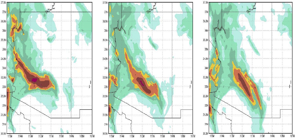
For model verification, we rely on a regionally sparse network of in situ sampling stations to compare model-generated concentrations of particulate matter with sizes of 10 and 2.5μm (PM10 and PM2.5, respectively). These networks are concentrated in densely populated urban areas, subject to PM10 and PM2.5 sources generated by human activity. Few particle-sampling sites are available that identify natural versus man-made sources. Future work will address these problems, distinguishing seasonally changing surface characteristics and turning to lidar (light detection and ranging) networks and the A-Train's (NASA's ‘Afternoon’ satellite constellation) CALIPSO (Cloud-Aerosol Lidar and Infrared Pathfinder Satellite Observation) and Glory satellites for measurements of aerosol profiles with which to compare model output. To improve the accuracy and usefulness of simulations and forecasts, DREAM-NMM has been tested at 3–5km spatial resolution (see Figure 4). It is currently being installed on the University of Arizona's supercomputer, which will yield greater detail and a wider spatial domain.
Products specifically designed with the end user in mind are being evaluated in key Arizona and New Mexico state offices with operational health and air-quality responsibilities. These products will be modified as needed for public-health services.
This work is sponsored by NASA's Science Mission Directorate, Applied Sciences and Public Health Programs. We acknowledge other members of the PHAiRS team, especially Karl Benedict and Len Flowers, and former members Dazhong Yin and Patrick Shaw, and early contributions and advice by Slobodan Nickovic.
William Sprigg leads interdisciplinary teams aimed at simulating and predicting atmospheric processes and the dispersal of airborne material. He recently led international drafting of the plan for a World Meteorological Organization ‘sand- and dust-storm-warning advisory and assessment system.’ Much of his career has focused on science policy.
Brian Barbaris' interests are educating next-generation laboratory chemists, drawing upon his experience in US Navy and university laboratories and state air-quality offices, collecting and analyzing air and water samples, with publications that include catalysis, water contaminants, and airborne dust. He has led model validation and verification for PHAiRS.
Stanley Morain is a biogeographer with current interests in syndromic surveillance related to respiratory illnesses in the American southwest. He leads a multi-university, multidisciplinary team to develop tools for health information and decision making. His career has focused on remote sensing and spatial analysis.
Amelia Budge manages several NASA-sponsored projects focusing on environment and public health. As a fellow of the American Society for Photogrammetry and Remote Sensing, she chairs the International Society for Photogrammetry and Remote Sensing's (ISPRS) working group on public health, organizes ISPRS conferences, and represents ISPRS on the Group on Earth Observations-User Interface Committee. She has coauthored several papers on the NASA-REASoN (Research, Education, and Applications Solution Network) PHAiRS project.
William Hudspeth's interests focus on open-source Web-based applications that support public-health decision-support systems. He recently developed interoperable, standards-based (OGC: open geospatial consortium) and service-oriented (SOAP: simple object-access protocol) visualization and analysis tools for the PHAiRS project.
Goran Pejanovic's expertise and interests in mathematics and atmospheric sciences is essential to code and facilitate the dust models for high-performance computer operations. He has worked on dynamical numerical-model codes for weather and climate systems, natural environments, and oceanographic circulations using massive parallel computing.